GRSF Records - an overview
This page provide the overall requirements for the development of the Global Record of Stocks and Fisheries (GRSF). The requirements were updated during the entire period of the project. "GRSF Records - an overview Version 1" (stored in iMarine at https://goo.gl/T6gkHa) wraps up the discussions held from the BB Kick-off meeting (September 2015) through the TWG1 (March 2016) until August 2016. The version "2" https://goo.gl/1V3pdw reflects the recommendations made at the TWG2 (28 February - 2 March 2017). The version 3 https://goo.gl/KWraAN was to guide the release of a new version of the GRSF application. The version 4 follows the discussions held at the EAB TWG3 - FIRMS TWG6 on GRSF meeting (Feb. 2018) and it is the final version for the release of the GRSF pilot dataset in the GRSF VRE.
This page summarizes the requirements collected from the FAO, FIRMS, FishSource and RAM representatives with highlighted outstanding issues and proposals.
It contributes to Deliverable 5.2 Blue Assessment VRE Integrated Resources.
Revision history

* Version 1 - July 2016 https://goo.gl/T6gkH

* Version 2 - March 2017

- General editing updating to the latest discussions
- Addition of proximities rules
- Update of the section "Draft guidelines for mapping to GRSF standards" and "Detailed draft guidelines for mapping of area fields"
- Update of the section "GRSF Semantic IDs and GRSF standards"
- Update of the section "Content Management System", consistently with the features offered by the CKAN based iMarine Data Catalogue

* Version 3 - October-December 2017

- General editing updating to the latest discussions
- Addition of "GRSF Record Validation" section
- Addition of the sub-section "Other standards" in the "Detailed draft guidelines for mapping of area fields" section
- Update of the section "UUID for traceability"
- Update of the section "Fields of the GRSF record and rules for importing"
- Removal of the paragraph about the GRSF prototype (2016)


* Version 4 - March-April 2018

- General editing updating to the latest discussions held at the EAB TWG3 - FIRMS TWG6 on GRSF meeting (Feb. 2018)
- Revision of the Fishery semantic identifier logic and related definitions
- Updating the GRSF requirements according the decisions taken during the call on 15th March 2018  [[18-03-15-GRSF_validation]]
i) Types of GRSF Fishery records, ii) Revision of area fields for Fisheries, iii) Management Authorities, iv) Marine Resources identification,
v) Assigning UUIDs to Marine resources and Other fishery (formerly labelled as Fishing description), vi) Assessment areas, vii) FIRMS definitions, and viii) Stock status descriptors.
- Table of contents
- GRSF Records - an overview
- GRFS Information domains
- Creation of GRSF records
- Stock monitoring evolution and Fishery life cycle
- Competency Questions
- Content Management System
- Citation
- Downloads
- Pending Issues
- Documentation and working files
GRSF Vision: an innovative environment supporting the collaborative production and maintenance of a comprehensive and transparent global reference set of stocks and fisheries records that will boost regional and global stocks and fisheries status and trend monitoring as well as responsible consumer practices.
FIRMS, FishSource and RAM are the three database sources from which information is extracted and rearranged to form GRSF records. The resulting GRSF records are then grouped into "families" of stocks/fisheries based on specific proximity criteria.
Note: The GRSF does not generate new data, but rather collates information coming from the different database sources, facilitating the discovery of inventoried stocks and fisheries. Due to heterogeneity of data and underlying classifications contained in the data base sources, the GRSF knowledge base needs to accommodate the incoming flow of information in a flexible way in order to allow these different classifications. Standard classification systems have been identified and adopted by GRSF, consequently the source information have been updated or mapped to the GRSF standards. It might occur that users will not find in the GRSF mapped values the same resolution of the source data, however the source data will be always visible and accessible.
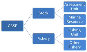
GRFS Information domains
The GRSF database collects information on two domains, generically identified as “stocks” and “fisheries”. Each domain includes different types.
Types for stock: 1) "Assessment unit", whenever a stock assessment is conducted; 2) "Marine Resource", when there is no stock assessment available.
Types for fishery: 1) "Fishing unit", a record bound to the fishing operation aspects; 2) "Other fishery" includes the identification of other fisheries described under different approaches (e.g. jurisdiction, management unit, fishery resource, production system). The different types were conceived following the overall strategy to be as inclusive as possible in the importing process, while still be able to distinguish different "kinds" of GRSF records functional to the three business cases:
1) Traceability purpose;
2) Comparison of stock status;
3) Links to all records for data management.
See GRSF Definitions page for the complete description of domains and types.
Creation of GRSF records
The fields of the GRSF records are populated by information harvested from the three sources. The information constitutes the GRSF knowledge base. Not all FishSource/FIRMS/RAM information is imported, but only selected subsets of data are processed to produce the new GRSF records. The original data remain unaltered. The GRSF has two domains: Stock and Fishery, each with a set of specific elements. Each GRSF field contains data in free text or any standard used in the sources (details are described in the Excel file GRSF_MinimumDataRequirements.xlsx http://goo.gl/DizvHa).
The creation of GRSF records includes different processes:
- import of specific information,
- dissection of information,
- identification of overlapping source records,
- identification of similarity/proximity (including mapping among different classifications),
- validation of records and merging of overlapping source records to one single GRSF record,
- assignment of identifiers (see section on Universally Unique Identifiers (UUID) and Semantic Identifiers), and
- collation of time dependent information (catch time series, state and trend indicators,...)
Implementation rules for these processes are different for each field and their application is partly automated, but will also require expert intervention for validation. During the validation process, Flags can be added for SDG/Traceability and Connections can be established among stocks and fisheries.
Note: The time component ("Year") has not been considered as one single field of the GRSF record, since the minimum elements of the GRSF records are time independent (e.g. species and area for stocks). Nonetheless, some of the accompanying information (e.g. catches, S&T indicators) is dependent upon time, and therefore a reference year is expected to be associated to each source record. The reference year is defined as the last year in which data is available. The latest update and past values for each time dependent field should be made available and accessible from the GRSF records.
Fields of the GRSF record and rules for importing
Stock
- Stock ID - Two types of IDs: UUID and Semantic ID (see ID section for related standard)
- Stock Name - Two types of titles: GRSF Title and Short Title (see details in section GRSF stock/fishery title)
- Species Scientific Name - ASFIS/WoRMS scientific name and code as provided by the source
- Assessment/Distribution Area - Assessment Area name and code as provided by the source
- Type - Controlled terms: Assessment Unit, Resource. RULE: RAM: all records are assessment units ; FIRMS: all records with stock status descriptors (including narrative text) is an assessment unit ; FishSource: FS type "stock" or "assessment unit" corresponds to a GRSF "assessment unit"; FS type "unascertained" corresponds to a "marine resource". For all stocks in which RAM is involved, (including all merged records with RAM) should be by default tagged as "Assessment Unit".
- Exploiting Fisheries - Links to GRSF fishery records, automatically inferred through mapping of area and species.
- Assessor - Only available for RAM (name and acronym when available) - TIME DEPENDENT (Reference Year)
- Catches or Landings - Tonnes associated to a year or a time frame - TIME DEPENDENT (Reference Year). A qualifier should be addedd to disntiguish the different catch/landing types (recreational, commercial, estimate).
- Assessment Methods - Name of assessment model - TIME DEPENDENT (Reference Year)
- State and trend of Stock - Qualitative description of the stock state and trend - TIME DEPENDENT (Reference Year)
- S&T indicator - Quantitative and/or qualitative values for fishing pressure (Exploitation rate/Fishing mortality) - TIME DEPENDENT (Reference Year)
- S&T indicator - Quantitative and/or qualitative values for abundance (Abundance/total biomass/SSB level) level - TIME DEPENDENT (Reference Year)
- Exploitation state - FAO standard terms TIME DEPENDENT (Reference Year)
- Scientific Advice - Narrative text TIME DEPENDENT (Reporting Year)
- Database Source - Links to specific records being harvested in FIRMS, RAM or FishSource
- Source of Information - Each piece of information has its own Citation of the Source/Bibliographic Reference and URL pointing to PDF/HTML in the website of the data owners, or (if grey literature) document uploaded - TIME DEPENDENT (Reporting Year)
- Data Owner - For FIRMS and FishSource is stored as "data owner", for RAM it is the "management authority" (name and acronym when available)
Note: Series of indicators from historical stock assessments
Different series of indicators deriving from historical assessments can be associated to one assessment unit. These should be reported in the GRSF, since keeping track of historical data is important. A qualifier (reference year, see also following recommendation item) should be associated to identify the particular assessment associated to the different data series. Also, what RAM has identified as the “preferred values”, among those available from the different assessments should be identified. For common usage the default display would be the most recent assessment among the multiple view options.
See GRSF stock status descriptors for detailed stock status descriptors provided by the GRSF data providers.
Fishery
- Fishery ID - Two types of ID: UUID and Semantic ID (see ID section for related standard)
- Fishery Name - Two types of titles: GRSF Title and Short Title (see details in section GRSF stock/fishery title)
- Species Scientific Name - ASFIS/WoRMS scientific name and code as provided by the source
- Fishing Area - Fishing area name and code as provided by the source
- Jurisdiction Area - Jurisdiction area name and code as provided by the source
- Type - Fishing unit, Other fishery. Rules for FIRMS/FishSource: when at least the fields "species", "gear", "flag state", "management authority" are available (beyond the compulsory area field) it is a Fishing unit, otherwise it is Other fishery.
- Exploited Stocks - Links to GRSF stock records.
- Management Authority - Official name and acronym when available as provided by the source
- Production System Type - This field is not mandatory. Rules: for FIRMS it is clearly specified in the XPath, for FishSource when available the types are Industrial or Artisanal.
- Flag State - ISO3 country code, or as provided by the source (plus custom solutions to manage exceptions)
- Fishing Gear - ISSCFG classification, or "SFP fishing gear classification"
- Catches or Landings - Tonnes associated to a year or a timeframe - TIME DEPENDENT (the year associated to the catch value). A qualifier should be addedd to disntiguish the different catch/landing types (recreational, commercial, estimate).
- Database Source - Link to specific records being harvested in FIRMS or FishSource
- Source of Information - Each piece of information has its own Citation of the Source/Bibliographic Reference and URL pointing to PDF/HTML in the website of the data owners (see below), or (if grey literature) document uploaded - TIME DEPENDENT (Reporting Year)
- Data Owner - Same as for stocks, as provided by the source.
Note: RAM only has type assessment unit (does not contribute to the domain Fishery)
Not all fields are mandatory. For stocks, mandatory fields for inclusion in the GRSF are: Species, Assessment Area, Database Source, Source of Information, Data Owner.
For Fisheries: Fishing area, Database Source, Source of Information, Data Owner.
Some fields accept multiple entries, others not.
Dissection process
In some cases, fisheries information in the source is aggregated and this makes a fine grained GRSF record impossible. Where possible, the Fishery records are disaggregated (dissected) into smaller elements. During the creation of the GRSF records, the following fields of the incoming information are dissected:
- Species Scientific Name - by target and associated species
- Flag State - by flag states
- Fishing Gear - by fishing gears
The fields Fishing Area, Jurisdiction Area and Management Authority will not be dissected.
The information in the Stocks domain is never broken down although source records could have multiple species.
The fishery indicators associated to GRSF records generated by dissection process should not be associated to the GRSF record itself, but to the source record.
Mapping and proximities
The information imported from the sources is described using different classifications. These can be local classifications (national or regional standards/classifications, or classifications created ad hoc within the database source) or global standards widely recognized at international level. Mapping of local standards/classifications to agreed standards adopted by GRSF is needed in order to harmonize the content of the GRSF and to compare the different GRSF records to identify overlaps and similarities (proximities). The standards adopted by GRSF will be preferably global standards. However, it is not always possible to map local classifications to global standards without losing a significant level of detail (for example, in the case of the field “Area”). In such cases, local standards would be eligible for adoption in the GRSF.
Proximities rules
In order to facilitate the validation process, the following proximity rules were compiled to identify similar records.
Stocks
- Same species + partially overlapping area (Example: Sardina pilchardus in GSA 17 and Sardina pilchardus in GSA 17, 18)
- Same species + adjacent area (Example: Sardina pilchardus in GSA 17 and Sardina pilchardus in GSA 18)
- Same genus + same / adjacent / partially overlapping area
Fishery
- Same species / genus + same / partially overlapping / adjacent fishing area + Same group of fishing gear
Groups of fishing gears are all the fishing gears under the same main category of ISSCFG classification (i.e. 01.0.0, 02.0.0, 03.0.0, 04.0.0, 05.0.0 06.0.0, 07.0.0, 08.0.0, 09.0.0, 10.0.0, 11.0.0, 20.0.0, 25.0.0, 99.0.0): http://www.fao.org/3/a-bt986e.pdf
A new classification was just released, with similar codes, and will be implemented from now on:
http://www.fao.org/3/a-bt987e.pdf
Correspondence between the two classifications is in the following document:
http://www.fao.org/3/a-bt988e.pdf
Area standards in GRSF
Standards on GRSF areas are needed to populate the following fields of the GRSF data model: 1) Assessment/Distribution Area and 2) Fishing Area/Management Area, respectively for the stocks and fisheries domain.
The GRSF is open to any area standard with the condition that such standards are properly referenced and maintained by an institution which uses these codes for assessment or management purposes.
The required metadata are the following:
- Area code
- Area name (in absence of it, can be the area code)
- Coordinates of the polygon
- Name of the Classification system/acronym
- Institution
As of today, the GRSF uses the following classifications:
- Exclusive Economic Zone (EEZ)
- FAO major fishing areas
- GFCM geographical sub-areas
- IATTC Pacific tuna reporting area
- ICCAT management unit
- IATTC reporting unit
- Large Marine Ecosystems (LME)
- Marine Regions Geographic IDentifier (MRGID)
- RFB area of competence
Summary of GRSF standards
| Classification System name | GRSF namespace | Code | Source | Example |
|---|---|---|---|---|
| Exclusive Economic Zone | eez: | ISO3 country code | https://www.marineregions.org/mrgid.php | eez: ITA |
| FAO Major Fishing Areas for Statistical Purposes | fao: | FAO codes (area, sub-area, division, subdivision, unit) | http://www.fao.org/fishery/area/search/en | FAO:27.27.3.d.26 |
| GFCM geographical sub-areas | gfcm: | GSA codes | http://www.fao.org/gfcm/data/maps/gsas | GFCM:5 |
| IATTC Pacific tuna reporting area | iattc: | FIRMS codes | FIRMS | iattc:NPO |
| ICCAT management unit | iccat: | FIRMS codes | FIRMS | iccat:SWO_N |
| Large Marine Ecosystems (LMEs) | lme: | LME codes | https://www.lmehub.net/ | lme:5 |
| Marine Regions Geographic IDentifier | mrgid: | MRGID codes | https://www.marineregions.org/mrgid.php | mrgid:8378 |
| RFB area of competence | rfb: | RFB acronyms | FIRMS | rfb:IOTC |
| ICES functional Units (for Norway lobster) | ices: | ICES codes | ICES | ices-nep:11 |
| ICES functional Units (for Sandeel) | ices: | ICES codes | ICES | ices-san:2r |
| GRSF | grsf: | GRSF custom codes | TBD | GRSF:21 |
| Unknown | unk: | Any code | GRSF data providers | unk:New Zealand-MFish-BOP |
In absence of a known standard, any non-standard codes are treated only as a text string and qualified as “unknown” (abbrev. in the namespace: "unk"). The list of unknown area codes are maintained by the providers of the GRSF database sources (FishSource, FIRMS, RAM, SDG14.4.1).
Addition of a new area standard in the GRSF
The GRSF data providers can update their area codes vs. an already established GRSF area standard, or by adding a new standard. In case of a new standard, for example a breakdown area of the national waters of New Zealand, the data providers submit the above mentioned key metadata (Area code, Area name, coordinates, name of classification system, institution) for its endorsement and inclusion in the GRSF knowledge base.
Guidelines for mapping to GRSF standards
Approved GRSF standards must include specifications on Classification system, CodeList and Titles (in multiple languages). Any non-standard code will be treated only as a text string and qualified as “unknown” (abbrev. in the namespace: "unk"). In case of multiple and overlapping standards, the preferred one will be that indicated by the competent authority. Bounding box coordinates are expected in absence of standard codes and mappings.
STOCKS
- Species Scientific Name - Any other classification mapped to ASFIS (FAO 3Alpha code) or WoRMS (If ASFIS code is missing). Any other scientific name can be entered in the GRSF but this will be treated only as a text string and not qualified. The mapping between the two standards should be made available (i.e. through the iMarine TLO) for species name validation and populating the semantic identifier.
- Assessment/Distribution Area - Any other classification mapped as appropriate to EEZ (from Marine Regions - MRGID) or RFBs geographic system (ICCAT management unit, GFCM geographical sub-areas, IATTC Pacific tuna reporting area) or FAO Area (and its subdivisions).
FISHERIES
- Species Scientific Name - Any other classification mapped to ASFIS or WoRMS (If ASFIS code is missing).
- Fishing Area/Management Area - Any other classification mapped as appropriate to EEZ (from Marine Regions - MRGID) or RFBs geographic system (ICCAT management unit, GFCM geographical sub-areas, IATTC Pacific tuna reporting area) or FAO Area (and its subdivisions). Note: Other area codes (under new standards) can be entered when the SFP project on "registry of national Management units" will produce new classification systems and new codes, in example for sub-national/species based management areas. (see also Management Authority)
- Jurisdiction Area - Any other classification mapped as appropriate to EEZ (from Marine Regions - MRGID) or RFBs areas of competence.
- Management Authority - The coverage of the existing GRSF repository of Management Authorities (i.e. a registry of local/national/international organizations/institutions with mandate on fisheries monitoring/management) is limited and “GRSF owned”. National authorities change across time and it may require huge efforts to maintain the information. So far it is enough to indicate the “national management" (with iso3 country code)” (and under which EEZ jurisdiction (ISO3/mrgid). Prefixes: "authority:NAT:", "authority:INT:"; other prefixes: "High seas", "SpecialAgreement". Note: The registry of national "Management units" (species, area, management authority, shape file) developed by FishSource (starting April 2018), will be integrated in the semantic identifier refining the fisheries identification with specific area classification systems and specific management authorities at national/sub-national level (e.g. "authority:Sub-Nat:XXX").
- Fishing Gear - any other classification mapped to ISSCFG classification or “SFP fishing gear classification”.
- Flag State - any other classification mapped to ISO3 country code (plus custom solutions to manage exceptions).
Since detailed mapping rules are not available for all fields, the first GRSF prototype accepted in the GRSF fields any codes as provided in the sources. However, for the final version of the GRSF it is expected the updating or mapping of all classifications to the agreed GRSF standards above described (see paragraph below "First Implementation (Autumn 2016)").
FIRMS, FishSource and RAM partially overlap in their data coverage. In some cases, GRSF records coming from different sources present complete or partial overlapping of information (regardless of the adopted standards). Final revision and validation of overlapping records and assignment of proximities will be done by expert.
Detailed draft guidelines for mapping of area fields
Draft guidelines for mapping non-GRSF local area codes (at national or supra-national level) to agreed GRSF standards are hereafter specified. In general, mapping for area codes are accepted for "same as" relationships. Alternatively, the bounding box coordinastes and/or detailed polygon coordinates should be provided.
Assessment area/Distribution area/Fishing area:
- For stocks identified at supra-national level (generally under RFBs), the standard should follow the geographic systems as defined by RFBs (including bilateral agreement): Statistical areas (e.g. CECAF), Geographic areas (e.g. GFCM), FMUs (e.g. ICCAT)
- In high seas, in absence of an RFB, FAO areas or coordinates for polygons/bounding box should be provided
- For stocks identified at national level, the EEZ identifier (from Marine Regions - MRGID) (e.g. WECAFC national stocks) and (if relevant) to RFB geographic systems or to FAO area (and its subdivisions)
- For stocks identified at sub-national level, the EEZ identifier or any other geographic system as defined by the concerned country, provided such system is approved as GRSF standard When applicable, preference should be given to adopt the same standards for both fishing area and assessment area, to univocally relate a fishery with an assessment unit. In case of absence of information the jurisdiction area is taken into account.
Jurisdiction area:
- For fisheries identified at supra-national level: any local value should be mapped to the RFB competence area (when available) or ’High Seas’
- For fisheries identified at national level: any local value should be mapped to national jurisdiction (e.g. Australia EEZ , US EEZ) and (if relevant) to the concerned RFB area of competence (e.g. ICCAT, CCAMLR).
- Additional eligible local standards might be adopted. Bounding box coordinates are expected in absence of standard codes and mappings.
Other standards:
- “Local” standards are eligible to be adopted as standard if not already covered by existing GRSF standards, and if commitment for its maintenance is provided.
- The underlying local standards for RAM areas should be investigated, possibly liaising with the local agencies owning the local standard. A commitment to maintain those local classification should be ensured.
- Requests to national and local agencies to provide their coding system should come from FAO. Identification of contacts to be established among partners.
- Apply caution in importing too much detail for stock location in GRSF if the information is already available at source, as it can decrease user clarity.
Use of geographical coordinates
Adding coordinates (bounding box or polygon) in the identifiers would be the last-last option in absence of a GRSF standard, an eligible local standard or mapping rules.
The ultimate standard to build on would in fact be the 1x1 or 5x5 degree quadrangles; and ways to map the bounding box coordinates (which are somewhat random) to this grid standards as overlay best fit, then only build the semantic identifier on these grid standards. See also CWP Handbook recommendations at http://www.fao.org/cwp-on-fishery-statistics/handbook/general-concepts/major-fishing-areas-general/en/
GRSF record identifiers
UUID and Semantic identifier
Two kinds of identifiers should be distinguished within the GRSF:
GRSF record identifiers: these are unique, do not expect to change and are assigned to approved GRSF records. They are used for identification and traceability purpose of GRSF records. As much as possible, it is recommended to model a parent GRSF record and handle historical records built depending on the workflow actions (approve, update, archive), instead of creating separate GRSF records, and in order to keep track of the GRSF history of a record. For implementation of record identifiers (parent and eventually historical records), It is suggested to use the standard Universally Unique Identifiers (UUID)[1]
RULE: (For the sake of “uniqueness” of Marine Resource and Fishery records) UUIDs for specific GRSF types (i.e. marine resource, other fishery) can be assigned to specific policies and hidden to end-users. See also pending issues on "Unassessed resources and traceability".Semantic identifiers: (what has been described so far as UUID in the previous discussions), built from the record annotating concepts is expected to serve the traceability purpose of the GRSF initiative. The Semantic ID is made of two components: the code and the label (GRSF Title). Such identifier follows a specific coding system, which results in a concatenated encoded string, which can be decoded for fast discovery / access to a GRSF record. Contrary to the UUID, they are not used as physical record identifiers, and expect to change (dynamic identifiers). For a given GRSF record there are as many semantic identifiers as source records. This distinction with UUIDs allows retrieving GRSF records based on the annotating concepts even those from a source record that has not been selected as main source of information according to a conventional priority order: FIRMS>FISHSOURCE>RAM.
Furthermore, the semantic identifiers complements the UUID by offering a human readable code and label which can ultimately be the skeleton of the label associated to any inventoried fishery resources.
[1] https://www.iso.org/standard/62795.html
Why unique identifiers for each GRSF record? The ambition of the GRSF is to become the authoritative overview of stocks and fisheries. With a Universally Unique Identifier (UUID) the GRSF overcomes the problem to provide access to data that is described using different classification schemes.
- Universally Unique Identifiers (UUID) will be assigned to each unequivocally identified stock or fishery in the GRSF.
- UUIDs are assigned to GRSF records, not to source records. All sources contributing to the same GRSF record will be referenced to the GRSF record UUID.
- The number of records coming from different sources equals to the number of dynamic identifiers that should point to the same UUID record.
IDs examples (based on cases provided by FIRMS, FishSource, RAM) area available at http://goo.gl/0RLZ8f (GRSF_UUIDs.xlsx Worksheet "Examples"; Worksheet). See the worksheet (GRSF_ID_Scenarios) that explains the need to distinguish GRSF record identifiers (UUIDs) and Semantic IDs (dynamic IDs).
GRSF Semantic ID principles
- The Semantic IDs (or dynamic IDs) are envisaged to support three use cases: 1) Traceability 2) Stock status 3) Data management.
- Semantic ID components for stocks, codes for: Species Name, Assessment/Distribution Area
- Semantic ID components for fisheries, codes for: Species Name, Fishing Area/Management Area, Management Authority, Fishing Gear, Flag State
- Semantic ID code: concatenation of all available information in the ID proposed components according to selected standards and mapping rules.(Local values should be mapped to GRSF standard values)
GRSF Semantic IDs and GRSF standards
The discussions held so far highlighted the complexity of conciliating different standards, particularly for the area classifications in which several classification systems have been adopted in FIRMS, FishSource, RAM.
A proposal is hereafter formulated.
The semantic identifier is populated with standard codes as direct entry or mapped or, where not available, with the local codes. The structure of each semantic identifier component should be made of the “standard qualifier (referencing the classification system) plus the code”, i.e. “ISSCFG:.3.1.1” or “ISO3:BVI”. The qualifier for unknown classification system is “unk".
Prefixes for Management authority: "authority:NAT:", "authority:INT:"; other types of authority: "High seas", "SpecialAgreement".
At display level the components of the semantic identifier should be separated by a specific delimiter (e.g. “+”), empty codes should be also reported with a space or equivalent (TBD). Multiple values should be comma separated or equivalent.
Stock: <Species> + <Assessment Area(s)>
Fishery: <Species> + <Fishing Area(s)> + <Management Authority(ies)> + <Gear type> + <Flag State>
Examples:
ASFIS:COD + FAO:21.3.M
ASFIS:COD + FAO:21.3.M + authority:INT:NAFO + ISSCFG:03.1.2 + ISO3:CAN
ASFIS:SLC + EZZ:BHS (or MRGID:8404) + authority:NAT:BHS + ISSCFG:20.0.0 + ISO3:BHS
The UUID resolver (i.e. http://data.d4science.org/ctlg/GRSF_Admin) can be customized, the UUIDs persist in case of changes of the semantic identifiers (i.e. updates of a record).
DSDs for each standard need to be provided to the GRSF knowledge base, and must be used to align terminology in GRSF.
The first GRSF prototype is accommodating any incoming standards/classifications, as no mapping rules to agreed GRSF standards (with appropriate level of detail) were available. The Semantic ID in this phase is populated with the local codes (from the local classifications) with the concatenation mechanism above described. Each GRSF record has its own semantic id. Due to the lack of standards, no mergining of overlapping source records was possible in the first GRSF prototype. Once standardization of codes is implemented, the semantic id of the GRSF records will be constituted of the standard codes.
Generally speaking, some of the above area classifications are not authoritative sources (in particular the EEZ geographic representation). However, the conventional priority order “FIRMS>FishSource>RAM” clearly indicates that area classifications considered as standard for a priority source are accepted as such by other data providers.
Example: in case of 3 records, the areas (including EEZ) referenced in the FIRMS record will be accepted by all data providers as suitable area for the GRSF record.
The mechanism described so far will produce a flat list of GRSF records, each one with its own UUID and Semantic ID. This list can be filtered to group records into families of "associated" records according to local or mapped values.
GRSF records can be grouped/filtered by different criteria based on GRSF standards. The GRSF application suggests the positioning of records at different resolution with local standards according to the available mapping rules, a final approval is expected by an expert revision.
It has been noted that in FIRMS some different stocks are described with same species and area codes. This occurred due to lack of detailed area information. So far this will produce identical semantic identifiers and stock title (not the short title), however the UUIDs will be different for each stock.
GRSF stock/fishery title
For the GRSF records, two types of names are envisaged:
- the GRSF Title (label of the Semantic ID) is the concatenation of the decoded values of the Semantic ID (code), and
- A short title, user friendly and manually entered according to specific naming conventions (e.g. FIRMS standards). If the GRSF record is the result of a merging activity and more than one record contribute for this, then the short name is derived from the original records based on the following priority (FIRMS > FishSource > RAM)
UUID for traceability
- FishSource requirement for traceability does not accept the relationship "one fishery to many stocks". A fishery can be flagged for traceability only if linked to one specific stock (assessment unit).
- When a unique relationship between a fishery and a stock (assessment unit) exists, there should be the possibility to concatenate the fishery semantic identifier with the stock UUID. The GRSF Admin Management panel should give the option to flag/un-flag the record for traceability purposes and add/remove link to a specific stock UUID.
- All approved records in GRSF will have a UUID, and one or more possible dynamic IDs depending on the number of source records associated to the GRSF record. The records with type "Fishing unit" are flagged in the GRSF knowledge base for traceability (when the above requirement is fulfilled), as in this type all the relevant information is present. It appears from recent discussions that the field Production System Type is not mandatory for traceability (see pending issue on Production System Type).
- Semantic identifiers do not have detailed indication on hierarchies. Records will be clustered together following the established proximity rules to detect potentially overlapping records and/or monitoring evolution within the validation process. The GRSF will be a flat list and any clustering will be possible through facilities offered in the interface (e.g. groups, tags, search).
Connecting stocks to fisheries, best practices
GRSF Records validation
- Overlapping source records: All the information from the different database sources is kept and collated in different fields.
- Unique source records: There is no need for particular protocols for unique stock/fishery identification.
- Similar source records: Groups of similar records (identified thanks to the implementation of proximity rules) will be analysed by the validator to assess the relationship among them (e.g. monitoring evolution, partially overlapping assessment units). Assessment units that are no longer monitored and have evolved into a different assessment unit should be flagged as archived. If assessment units are partially overlapping, these should be annotated in a comment (available in the GRSF including the downloads) warning the user and linking to the overlapping records. Hence the “Manage item” in the cms panel should contain an additional field for comments to users under selected categories (i.e. controlled terms: inconsistencies encountered; partial overlapping etc.). The development team should propose a narrow/broader indication and ranking system for similarities to further facilitate the validation process (i.e. based on the percentage of area overlapping, species vs. genus, gear categories). Therefore, in the Admin VRE, an interface highlighting groups of similar records should be made available to the validator. On the other hand, in the public GRSF VRE, a feature clearly marking partially overlapping records and archived records should be implemented. The catalogue should also offer the possibility to flag and browse records along the above proximities rules.
- Scientific names: The validator should ensure that scientific names are compliant with ASFIS classification, and when not available with WoRMS.
- Source Content validation: Inconsistency issues will be initially solved internally (by reporting back to the owners of the database sources), if this is not possible they will be flagged externally to users (as above described).
- Quality assurance The owners of the database sources should ensure that a quality control process is in place before submitting data to the GRSF.
Following the FAO&UW LoA (January-October 2022), guidelines for GRSF Records validation are available at Documentation and working files: GRSF Records validation guidelines
Stock monitoring evolution and Fishery life cycle
Assessment units might change across time, and the GRSF needs to capture this evolution. Similarly, fisheries have a life cycle (they might open, close or be suspended). See CMS paragraph for specific actions.
Competency Questions
The competency questions give access to stocks and fisheries stored in the GRSF through SparQL endpoints and/or a user interface.
See full list of queries at Competency questions, they have been grouped into three categories to highlight the use according to the 3 business cases: 1) Traceability 2) Computation of stock status 3) Links to all records for data management.
Queries for the imported data (not yet processed) are also available.
The export functionality is expected to offer formats easily usable (csv, excel).
Traceability purpose
- Retrieve/Count/Download-Export all records flagged for traceability purposes
- Retrieve records according to the following parameters Species Name / Area / Management Authority / Production System Type / Flag State / Fishing Gear
Analysis of stock status
- Retrieve/Count/Download-Export all records according to the type (assessment unit, resource, fishing unit, ...)
- Retrieve all records for which a state and trend evaluation is available (e.g.: low biomass, high fishing mortality) - Qualitative values
- Retrieve all records for which abundance level/mortality is below/above a certain value (e.g.: >1) - Quantitative values
- Retrieve records according to a specific state and trend value (qualitative or quantitative) or a combination of two (one specific level of abundance and one of exploitation rate)
- Retrieve all records from a region (e.g. certain ocean) or by taxa/main groups (e.g.: all squids from a certain region)
- Retrieve all stocks for which a specific term is contained within the linked PDF document (e.g.: retrieve all stocks for which the word "hyperstability" is present in the pdf doc)
- Retrieve time series of values (resulting from subsequent updates of the record) for any of the time dependent fields for a particular stock
- Retrieve all stocks above trophic level "4" (linkages with fishbase)
- Retrieve stock status by management authority
Data management
- Retrieve/Count/Download-Export all GRSF stock records with names and sources
- Retrieve all records with names and sources according to Type (assessment unit, resource, fishing unit, ...)
- Retrieve all GRSF stock records with names and sources by Type
- Retrieve GRSF records grouped by similarities (e.g. same species similar areas, similar gear codes etc..)
- Retrieve all GRSF records by CMS status (rejected, pending, etc.)
- Retrieve all GRSF historical records for a given GRSF record (evolution of a GRSF record across time)
Content Management System
The CMS for the GRSF has been developed with the CKAN technology as part of the iMarine Data Catalogue.
Access the GRSF Admin at https://i-marine.d4science.org/group/grsf_admin and the GRSF VRE at https://i-marine.d4science.org/group/grsf/data-catalogue
Functions
- Approve-Reject pending records
- Identify and merge overlapping source records
- Identify similarities. Track monitoring evolution (e.g. indicate the former monitored record or the descendant. See FIRMS standard)
- Provision of clustering facilities (by species, gear, area…)
- Validate records content and annotation of issues (e.g inconsistencies in the data)
- Archive GRSF record (e.g. fishery life-cycle)
- Publishing workflow
- Connect assessment units with fishing units
- Flag records for SDG and/or for Traceability
- Manage code lists and mapping
CNR suggested to use the iMarine Catalogue Service. So far the catalog is giving access to individual records as well as providing a free text search tool and a content browser through tags.
Possible tags:
- List of available species in the GRSF
- List of FAO Areas
- List of stock/fishery types
- List of stock status controlled terms
- List of fishing gears
- List of flag states
- List of management entities
Citation
The VRE offers a way to cite each single GRSF record. Here follows the template for a GRSF record citation and how to cite the source records. (RAM cites the entire database)
Citation template for GRSF records
© [Copyright holder]. [Title]. ([Year]). In: Global Record of Stocks and Fisheries (GRSF). [Publisher]. Version: [Version]. Updated [Update date]. [Date accessed and/or downloaded [Access date]]. [GRSF Record URL].
Database sources: [Database sources].
Sources citations: [Citations to the database sources]Citation template for FIRMS source records
[© FAO] [Date created]. [Title of content]. [Series title]. [Contributors]. In: Fisheries and Resources Monitoring System (FIRMS) [online]. Updated [Update date]. Accessed [Date accessed and/or downloaded]. [URL]Citation template for RAM database
RAM Legacy Stock Assessment Database. ([Date created]). Version: 4.35. Updated [Update date]. Accessed [Date accessed and/or downloaded]. Retrieved from http://ramlegacy.org/Citation template for FishSource source records
© SFP. [Date created]. [Title of content]. [Series title]. [Contributors]. In: FishSource [online]. Updated [Update date]. Accessed [Date accessed and/or downloaded]. [URL]
Downloads
The EAB TWG2 on GRSF produced recommendations on the downloads. Different versions of time series coming from different assessments are collated and properly distinguished by the addition of the field "Reporting year/Assessment version".
Examples were provided during the TWG2 in the following file: https://goo.gl/IqSfE3
Final development includes the following fields:
- reference_year
- value
- unit
- db_source
- data_owner
- reporting_year_or_assessment_id
Pending Issues
Unassessed resources and traceability
How to capture in the GRSF the unassessed resources and the need to track them through traceability systems.
For further background and details: https://docs.google.com/document/d/1qJACB-AXhOu3eUrfTb-IO-raXaJoWXYq4ZukMrvyxY0/edit (GoogleDoc)
Proposal:
- Allow addition of unassessed resources to the stock record. Require areas be specified, corresponding to the distribution area for the species minus existing assessment areas. These areas could be either added or inferred. At most one unassessed resource record would be permitted per species
- Consider not including area codes for unassessed resources in the semantic ID, replacing them instead with a generic term such as “unassessed”
- Allow these records to be associated with fishing unit records, in the way that is currently under development, and to be both flagged for traceability and have a published UUID
- Develop a rule that when a new assessment unit is added, an alert is raised for the fisheries associated with the existing unassessed record for the same species. Associations between that unassessed record and fishery records would then need to be reviewed
Assessment areas
RAM highlighted that the assessment area portrayed in the GRSF in some cases does not reflect the resolution submitted (example FU6 is smaller than 27.4.b). Considered that mapping is based on "same as" relationship, cases like "FU6" should not be mapped to standard GRSF area codes if not fully matching the area definition. Since there is no GRSF standard to properly represent ICES area FU6, it can be entered in the GRSF but under the "unknown" classification system.
Discussion
The group confirmed the issue, however to facilitate the validation process it was suggested to leave that mapping and one by one confirm or reject the merge proposals.
i) RAM confimed that FU codes are already in their database.
ii) Medium term solution: the ICES classification system of FUs and other areas will be added as part of the GRSF standard classifications systems. In such case, FIRMS, RAM and FishSource data should be updated or mapped accordingly.
Previous discussions
See also minutes for finalizing the GRSF requirements at March 15, 2018 - Finalizing GRSF requirements
Management Authority - Management Unit
Authorities with a certain mandate. The notions of Management system and Management unit are here recalled (from FishSource). See also referenced Word file as per FishSource follow-up reply to the GRSF call of 14th of July 2016 (FishSource_AboutManagementEntity-ManagementUnitConcepts_July2016.docx).
Management system
One or more management systems may have jurisdiction over a resource, and thus the responsibility to regulate the fisheries conducted upon that resource. The management system may be the product of a national management authority or a regional or even smaller-scale authority or management instrument. Alternatively, two countries may agree to manage jointly a shared stock through a bilateral agreement, or multiple countries may have management responsibilities within an agreement such as a regional fishery management organization (RFMO).
Management unit
A management system may operate at the international, national, regional, or even smaller scale. One management system may manage the same species differently in different fishing areas. A management unit can thus take a diversity of forms but can be defined as the most basic unit wherein one or more management organizations, within a defined fishing area, distinctly manage a particular resource.
FishSource highlighted the importance of the management authority(ies) for traceability purposes for evaluating the quality of the management (attention to sustainability, management goals etc.). In case of multiple management entities, the one issuing the binding management measures is the relevant one.
Some fisheries described in FIRMS and FishSource do have multiple management entities which represent different levels of co-management although these are not fully described nor there is any unique criteria for distinguishing. So far, such information is envisaged to be captured and the field jurisdiction area is associated to that.
Is it important to have the management authority in the semantic identifier?
Is there a clear criteria to distinguish which are the management entities as the legitimate authorities and issuing the binding measures?
And if available, is this the criteria for dissecting multiple management entities?
Area
The area concept can have different interpretations: 1)"Assessment/Distribution Area" (the stock geographic extent, which can be the area(s) of distribution of the stock or the conventional stock assessment/monitoring area); 2)"Fishing Area" (the area in which the fishery is operating); 3)"Jurisdiction Area" to describe the mandate area of a management authority. I.e. FishSource and FIRMS fisheries with fishing activity / management unit approaches contain such types of areas.
These heterogeneity brought at the conclusion that one area type is needed for Stock while two different fields are needed to describe the multifaceted Fishery domain.
The fisheries semantic identifiers will be populated with fishing or jurisdiction area. What is the more relevant area type to be included in the Semantic ID?
Documentation and working files
Details and meetings notes are stored in:
- GRSF Definitions
- GRSF Stock status descriptors
- Elements of the GRSF database (GRSF_MinimumDataRequirements.xlsx , Worksheet: MinimumDataRequirement_May2016) http://goo.gl/DizvHa
- Unique Identifiers (GRSF_UUIDs.xlsx, Worksheet "Examples"; Worksheet "UUID_Principles") http://goo.gl/0RLZ8f
- Competency questions
- GRSF KB - (Tools and Services for supporting the construction of the GRSF Knowledge Base, technical description by FORTH)
- GRSF - (GRSF Wiki gateway page)
- About Management Authority and Management Unit concepts - FishSource follow-up reply to the GRSF call of 14th of July 2016 (16 KB) https://goo.gl/0aBPkA
Meeting reports
- FIRMS FSC10 Report http://www.fao.org/fi/static-media/MeetingDocuments/FIRMS/FIRMS_FSC10/FIRMS_FSC10_Report.pdf
- EAB TWG2 on GRSF report http://www.fao.org/fi/static-media/MeetingDocuments/BlueBRIDGE/EAB-TWG2-GRSF/EAB-TWG2-GRSF_REPORT.pdf
- EAB TWG1 on GRSF report ftp://ftp.fao.org/FI/DOCUMENT/FIGIS_FIRMS/TWG5/FIRMS-TWG5-Report.pdf (See Global Record of Stocks and Fisheries - Agenda Item 7)
locked

