Bug #19730
closed
LME areas interpreted somehow as GFCM areas
90%
Description
There are some records in FIRMS for which the assessment area is based on LME code system (e.g. LME 6 http://firms.fao.org/firms/resource/10925/en) but the corresponding GRSF record is indicating a GFCM area code (gfcm:6) thus creating a wrong GRSF name etc. See for example:
http://data.d4science.org/ctlg/GRSF_Admin/747a8885-ca82-31fa-b73d-fdcba90fa9e5 Rhomboplites aurorubens - Northern Spain vs. Vermillion snapper - Southeastern Atlantic coast of the USA
FIRMS source: http://firms.fao.org/firms/resource/10925/en
http://data.d4science.org/ctlg/GRSF_Admin/968e7295-3466-3085-98ea-108951167c06 Rhomboplites aurorubens - Balearic Islands vs. Vermillion snapper - Gulf of Mexico USA waters
FIRMS source: http://firms.fao.org/firms/resource/11032/en
Files
| tag_5_lme-gfcm.png (47.3 KB) tag_5_lme-gfcm.png | a fao area tag which is the same of a gfcm gsa tag | ||
| Issue19730.xlsx (11.7 KB) Issue19730.xlsx | |||
| Annotation 2020-08-06 162627.png (24.4 KB) Annotation 2020-08-06 162627.png |
Related issues
 Updated by Yannis Marketakis almost 6 years ago
- Status changed from New to In Progress
- % Done changed from 0 to 10
Thanks for spotting this.
This occurs because the URI that is assigned for the identifier is the same for both CodeSystems (GFCM and LME). It is the same because it contains only the source (i.e. FIRMS), the type (i.e. water_area) and the code (i.e. 6).
As a result the generated URI (e.g. _:/firms/water_area/6) is connected with two CodeSystems.
I've already fixed this in the mappings, by including the CodeSystem in the URI to avoid this issue in the future.
Currently, I'll traverse over the records in GRSF KB to find those issues and update the records accordingly.
 Updated by Aureliano Gentile almost 6 years ago
with many thanks, indeed it is important to specify the codesystem as a pure numerical code could belong to different classifications.
Updated by Yannis Marketakis almost 6 years ago
- Status changed from In Progress to Feedback
- Assignee changed from Yannis Marketakis to Aureliano Gentile
- % Done changed from 10 to 90
The water areas have been updated and are properly distinguished.
Moreover, the affected records have been updated, 30 GRSF records with their corresponding legacy records in both VREs (GRSF Admin and GRSF Public).
Updated by Aureliano Gentile almost 6 years ago
- File tag_5_lme-gfcm.png tag_5_lme-gfcm.png added
with many thanks!
regarding the total number "30":
I checked through the catalogue and tags, and I see we have now 2 LME tags:
- Code 6 System lme Name Southeast U.S. Continental Shelf (9 records)
- Code 5 System lme Name Gulf of Mexico (18 records)
so total is 27 (actually 25 records and 27 occurrences, and not 30), but you may have an explanation for that. In any case in FIRMS there are 25 stocks with LME which is consistent with the above results as two of them have both LME 5 and 6. So it seems fine on FIRMS side, except for the additional 3 records/occurrences you referred.
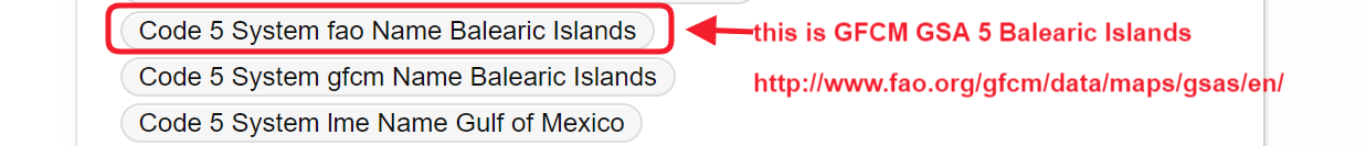
Please note the attached screenshot. As code "5" I see now both FAO and GFCM, I clicked on the tag "Code 5 System fao Name Balearic Islands" and I see those are fishsources records. That is wrong, it is a GFCM GSA http://www.fao.org/gfcm/data/maps/gsas/en/ not a FAO area code stricto sensu. Can you fix it or should we warn FishSource team?
@emmanuel.blondel1@gmail.com please check if we need to update the grsf map viewer accordingly (LME codes in place of gfcm GSA codes)
Updated by Yannis Marketakis almost 6 years ago
- File Issue19730.xlsx Issue19730.xlsx added
- File Annotation 2020-08-06 162627.png Annotation 2020-08-06 162627.png added
Attached you'll find the records that have been updated. As you see we've updated also records having GFCM areas as well.
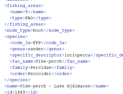
As regards your question about fao 5 areas. Indeed these are FishSource records, and this type of information exist in the harvested data (see screenshot attached).
Of course, this is something we can change (manually), however have in mind that since this is an issue with the data themselves, we will face the same issue when we refresh GRSF.
Updated by Aureliano Gentile almost 6 years ago
I concur and I created this ticket https://support.d4science.org/issues/19744
So, unless other aspects, I guess this ticket can be closed. With many thanks!
Updated by Aureliano Gentile almost 6 years ago
- Related to Bug #19744: GFCM areas vs FAO areas added
Updated by Aureliano Gentile about 4 years ago
- Status changed from Feedback to Closed

