GRSF area standards
- Table of contents
- GRSF area standards
Area standards in GRSF
Standards on GRSF areas are needed to populate the following fields of the GRSF data model: 1) Assessment/Distribution Area and 2) Fishing Area/Management Area, respectively for the stocks and fisheries domain.
The GRSF is open to any area standard with the condition that such standards are properly referenced and maintained by an institution which uses these codes for assessment or management purposes.
The required metadata are the following:
- Area code
- Area name (in absence of it, can be the area code)
- Coordinates of the polygon
- Name of the Classification system/acronym
- Institution
As of today, the GRSF uses the following classifications:
- Exclusive Economic Zone (EEZ)
- FAO major fishing areas
- GFCM geographical sub-areas
- IATTC Pacific tuna reporting area
- ICCAT management unit
- IATTC reporting unit
- Large Marine Ecosystems (LME)
- Marine Regions Geographic IDentifier (MRGID)
- RFB area of competence
Summary of GRSF standards
| Classification System name | GRSF namespace | Code | Source | Example |
|---|---|---|---|---|
| Exclusive Economic Zone | eez: | ISO3 country code | https://www.marineregions.org/mrgid.php | eez: ITA |
| FAO Major Fishing Areas for Statistical Purposes | fao: | FAO codes (area, sub-area, division, subdivision, unit) | http://www.fao.org/fishery/area/search/en | FAO:27.3.d.26 |
| GFCM geographical sub-areas | gfcm: | GSA codes | http://www.fao.org/gfcm/data/maps/gsas | GFCM:5 |
| IATTC Pacific tuna reporting area | iattc: | FIRMS codes | FIRMS | iattc:NPO |
| ICCAT management unit | iccat: | FIRMS codes | FIRMS | iccat:SWO_N |
| Large Marine Ecosystems (LMEs) | lme: | LME codes | https://www.lmehub.net/ | lme:5 |
| Marine Regions Geographic IDentifier | mrgid: | MRGID codes | https://www.marineregions.org/mrgid.php | mrgid:8378 |
| RFB area of competence | rfb: | RFB acronyms | FIRMS | rfb:IOTC |
| ICES functional Units (for Norway lobster) | ices_fu_nep: | ICES codes | ICES | ices_fu_nep:11 |
| ICES functional Units (for Sandeel) | ices_sa: | ICES codes | ICES | ices_sa:2r |
| GRSF | grsf: | GRSF custom codes | TBD | GRSF:21 |
| Unknown | unk: | Any code | GRSF data providers | unk:New Zealand-MFish-BOP |
In absence of a known standard, any non-standard codes are treated only as a text string and qualified as “unknown” (abbrev. in the namespace: "unk"). The list of unknown area codes are maintained by the providers of the GRSF database sources (FishSource, FIRMS, RAM, SDG14.4.1).
Addition of a new area standard in the GRSF
The GRSF data providers can update their area codes vs. an already established GRSF area standard, or by adding a new standard. In case of a new standard, for example a breakdown area of the national waters of New Zealand, the data providers submit the above mentioned key metadata (Area code, Area name, coordinates, name of classification system, institution) for its endorsement and inclusion in the GRSF knowledge base.
Methodology- Best practices
Area standards for New Zealand
Results
For New Zealand (NZL) 94 areas were identified and defined, 54 from RAM database and 40 from FishSource.
The Excel with all defined areas can be found at https://data.d4science.net/EHC3
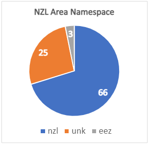
From the total 94 areas, a new namespace "nzl:" (e.g. "nzl:BCO1") is proposed for 65 areas that are clearly defined by the NZL Ministry of Fisheries (MFish). A total of 26 areas are not officially defined by the NZL authorities, as they are mainly defined for stock assessment purposes, and therefore their namespace will remain "unk:" (e.g. "unk:ORH3BNWCR"), although coordinates and other information is found in the Excel. Finally, 3 areas were identified as the whole NZL EEZ, and therefore will follow the GRSF namespace "eez:" (i.e. "eez:nzl").

Among the 94 NZL areas, GIS for mapping was found for 72 areas, with a Shape file ready to download and use. Coordinates are available for 20 areas, coming from documents or maps with coordinates but not as a file that can be downloaded and used. There are also 2 areas that could not be mapped and need further support for clarifying RAM records affected.
Methodology followed can be found at (FAO SharePoint): https://unfao.sharepoint.com/:w:/r/sites/NFI/Shared%20Documents/FIAS/Databases/GRSF/GRSF%20Areas%20analysis/NewZealand/NZL%20Areas%20Definition%20Methodology.docx?d=wbb15eef0baf346ec9a3f31b53ef1f948&csf=1&web=1&e=jm9rXo
Discussions
From: Taconet, Marc (NFISI) Marc.Taconet@fao.org
Sent: 17 November 2021 6:44 PM
Subject: RE: GRSF unknown area codes, finding the standards
... just commenting on few aspects:
It seems you are still working to identify areas for some of the listed stocks.
I trust you already searched across the various types of layers (e.g. New Zealand Statistical areas) listed in the New Zealand webpages with other layers listed here https://maps.mpi.govt.nz/wss/service/ags-relay/arcgis1/guest/arcgis/rest/services/MARINE
I am intrigued by the naming conventions such as MFISH (all records listed in the Excel file are with MFISH e.g. New Zealand-MFish-CRA1 ) . Looking at https://mpi.maps.arcgis.com/home/item.html?id=6b3c26319edb41f5a5fc111be477ab25 , could it be that MFish would stand for legally based Fishery Management Area type (MFISH), e.g. in the text they talk about the Spiny Red Rock Lobster (CRA) Management Area. But this doesn’t work with your finding that these are Quota Management areas
Then what are the QMA (Quota Management Areas), how do they differ from the MFISH
Time allowing, it will be good if Anne Elise can look at the NZ submission, extract stock identities and have Arturo check how these map to the RAM records
You may find the answers in Chris Free's database source, if not we may find channels to liaise with New Zealand, and this could be through the SDG14.4.1 focal point, unless you find directly contacts through the webpages.
Regarding findings for New Zealand and how these can contribute to the Management unit/Management Area standards (Ref FIRMS WG on terminology) and naming conventions
The CRA1 type of area seem to be fundamentally Species dependent, so I see two options:
- In the same way we have the ICCAT Yellowfin Tuna Fishery Management Unit (already in FIRMS), I would identify CRA1 as a combination of species code and Area code, and their name would logically be a Species name x Area name. So here I am not sure I would have it proposed as à asfis:LOR+nzl:CRA1 (GRSF name: Jasus edwardsii - New Zealand Northland)
- In the case of species dependent area, there is indeed some sort of duplication in a stock semantic identifier, since we already have Species in the stock name/identifier, and the above solution repeat the species in the area name/identifier. In this case, a solution is to properly classify the type of area (say this is a Fishery Management Area), we give a proper name space to this sub-type of area (say fmu:), and we name this stock à asfis:LOR+nzl:fmu:CRA1
I think we need to keep these options not settled at the moment and work them out as we progress in the findings of countries practices
Area standards for Australia
Results
Australia (AUS) areas definition work is in progress, with 40 areas identified. From these areas, 29 come from RAM database while 11 are from FishSource. The Excel file with the areas work in progress can be found at https://unfao.sharepoint.com/:x:/r/sites/NFI/Shared%20Documents/FIAS/Databases/GRSF/GRSF%20Areas%20analysis/Australia/GRSF_AUS_area_standards.xlsx?d=w073df01c45de4bbaa44d60c71d97dc68&csf=1&web=1&e=Gbvg1h
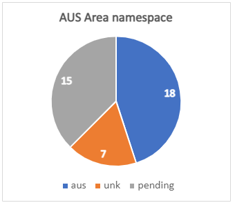
From the total 40 areas, 25 have been analyzed and defined. 18 of them will need a new namespace "aus:" (following the same criteria as NZL areas) as they are clearly defined by Australian authorities. The other 7 defined areas will remain with the namespace "unk:'' as they are either assessment areas or occurrence coordinates not responding to an official established area. 15 areas are pending further analysis.

25 of the defined areas are accompanied with a GIS Shape file that can be downloaded and used for mapping, while for the other 7 defined areas coordinates have been found (written in assessments or maps) that can be used for creating a GIS map.
Furthermore, many of the areas identified are formed by aggregating Provincial Bioregions of the Australian waters. These bioregions can be found at the third sheet of the Excel (IMCRA PBs) and can be found at:
https://data.gov.au/dataset/ds-dga-97978603-a359-450d-86dc-8f0a8b4deaea/details
Methodology for Australian areas definition is in progress and a link to the document will be shared when available.
Discussions
Area standards for United States of America
Results
United States of America (USA) areas definition just started, with 397 areas identified. Although some current records area codes are repeated, after a first check it was identified that each USA resource has its own area, and therefore repeated area codes will become unique and specific per species (area code ~ species x area). The areas seem to follow the GIS Data for Essential Fish Habitat (https://www.habitat.noaa.gov/application/efhinventory/index.html) although further analysis is needed.
The Excel for USA area definition in which work will soon start can be found at: https://unfao.sharepoint.com/:x:/r/sites/NFI/Shared%20Documents/FIAS/Databases/GRSF/GRSF%20Areas%20analysis/USA/GRSF_USA_area_standards.xlsx?d=w37d3d472bab74f70a558b642158675d9&csf=1&web=1&e=ecVkrl
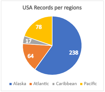
Four major USA marine regions were identified. From the total 397 USA areas, 64 are within the Atlantic region, 17 in the Caribbean, 78 in the Pacific and 238 are within Alaska regions (Alaska is considered as a separate region than Pacific).

All 397 areas identified come from RAM records, but in FIRMS and FishSource there are records whose coverage is within USA waters that will need further analysis (i.e. current "unk:31.2.2" and others).
Once methodology is ready for USA areas a document with all the information will be uploaded.
Discussions
Area standards for Canada
Discussions
Area standards for Argentina
Discussions
Resources
- iMarine workspace https://data.d4science.net/EHC3 (Workspace >VRE Folders >StocksAndFisheriesKB >Requirements >GRSF_AreaStandards)
- RAM Legacy Stock Boundary Database https://marine.rutgers.edu/~cfree/ram-legacy-stock-boundary-database/

