Task #17661
closed
Add the Filter by Location (spatial search facility for bbox) to GRSF_ADMIN Catalogue
100%
Description
The Spatial Search Widget has to be added to GRSF_ADMIN Catalogue in order to provide to end-users the Filter by Location (spatial queries for bounding box).
@aureliano.gentile@fao.org let me know if the facility (Spatial Search Widget) must also be added to GRSF Catalogue.
Files
| screenshot-bluebridge.d4science.org-2019.10.09-16_15_12.png (149 KB) screenshot-bluebridge.d4science.org-2019.10.09-16_15_12.png | |||
| BBOX PLACEHOLDERS Catalogue PRE.png (106 KB) BBOX PLACEHOLDERS Catalogue PRE.png | |||
| Capture.JPG (86.8 KB) Capture.JPG | area filter widget in grsf home page |
 Updated by Francesco Mangiacrapa almost 7 years ago
- Status changed from New to In Progress
Updated by Francesco Mangiacrapa almost 7 years ago
- Status changed from In Progress to Feedback
- % Done changed from 0 to 100
The spatial search facility has been activated by the Spatial Search Widget in the GRSF and GRSF_ADMIN catalogues.
For GRSF see at https://bluebridge.d4science.org/group/grsf/data-catalogue?path=/dataset
For GRSF_ADMIN see at https://bluebridge.d4science.org/group/grsf_admin/data-catalogue?path=/dataset
@aureliano.gentile@fao.org let me know if it's OK for you
 Updated by Aureliano Gentile almost 7 years ago
With many thanks!
We are making some tests and we'll revert to you.
At first glance I see that the due to the bounding box logic some results look not consistent (e.g. Atlantic big eye in a Mediterranean bbox selection) but that it is upon data and the computation of the bbox for the GRSF records, not upon the functionality of the widget.
Updated by Aureliano Gentile almost 7 years ago
- File screenshot-bluebridge.d4science.org-2019.10.09-16_15_12.png screenshot-bluebridge.d4science.org-2019.10.09-16_15_12.png added
Thanks again, the overall functionality seems fine. Here are our comments for your consideration.
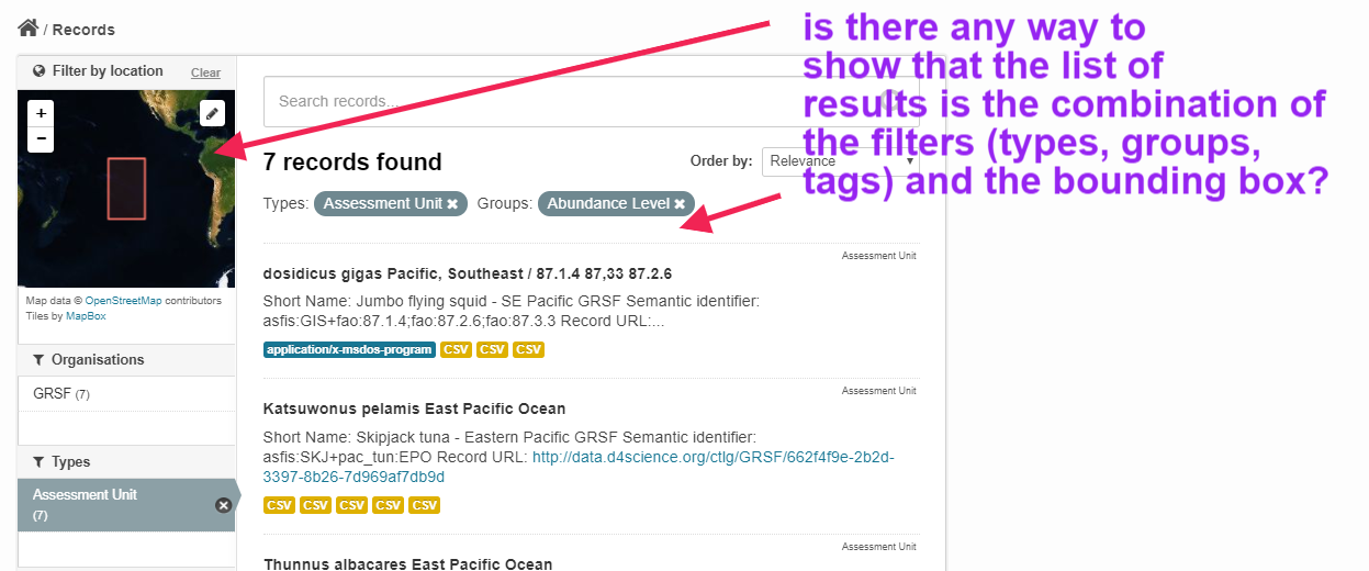
- We noticed the widget is displayed by filtering by "all records", "types" and "tags"; but it is not shown if filter by any groups. Any chance to have it?
- The "Filter by location" works also in combination with tags, groups etc. The point is that the user has no insight that the search results are the combination of selected filters (types, groups, tags) and the bounding box. Is it possible to display a "bbox" filter with the coordinates or something equivalent just to clearly indicate all applied filters for that specific result. E.g. Types: Assessment Unit Groups: Abundance Level Coordinates:[-142.1138,-55.4548],[-142.1138,59.2991],[-70.24,59.2991],[-70.24,-55.4548],[-142.1138,-55.4548]
- Any chance to have the widget also in the home page? ;-) https://bluebridge.d4science.org/group/grsf/data-catalogue?path=/dataset
Updated by Francesco Mangiacrapa almost 7 years ago
Hi @aureliano.gentile@fao.org,
thanks for your feedback.
Aureliano Gentile wrote:
Thanks again, the overall functionality seems fine. Here are our comments for your consideration.
- We noticed the widget is displayed by filtering by "all records", "types" and "tags"; but it is not shown if filter by any groups. Any chance to have it?
If I understood properly, you would like the Spatial Widget to be visible/working in the page of Groups (e.g. for "Abundance-Level" at https://bluebridge.d4science.org/catalogue-grsf?path=/group/abundance-level), at the moment, this task is not scheduled maybe in the future it will be.
- The "Filter by location" works also in combination with tags, groups etc. The point is that the user has no insight that the search results are the combination of selected filters (types, groups, tags) and the bounding box. Is it possible to display a "bbox" filter with the coordinates or something equivalent just to clearly indicate all applied filters for that specific result. E.g. Types: Assessment Unit Groups: Abundance Level Coordinates:[-142.1138,-55.4548],[-142.1138,59.2991],[-70.24,59.2991],[-70.24,-55.4548],[-142.1138,-55.4548]
The BBOX filtering when is active shows in the Spatial Widget the BBOX filter in action (as shown in the screenshot attached). Grouping of all applied filters as textual tags could be a future enhancements but it is not feasible in the short period.
- Any chance to have the widget also in the home page? ;-) https://bluebridge.d4science.org/group/grsf/data-catalogue?path=/dataset
Yes. I'm working on it (you can see the progress at #17678). I hope to release it before of your meeting in November.
Updated by Aureliano Gentile almost 7 years ago
ok thanks again, it is already a nice improvement and I understand the constraints. As you are saying, let's see if the widget can at least be activated in the home page, and for the rest "aspettiamo tempi migiori";-)
Updated by Francesco Mangiacrapa almost 7 years ago
Aureliano Gentile wrote:
ok thanks again, it is already a nice improvement and I understand the constraints. As you are saying, let's see if the widget can at least be activated in the home page, and for the rest "aspettiamo tempi migiori";-)
Exactly :-)
@aureliano.gentile@fao.org the Spatial Widget has been integrated (and it is under testing) in the Home Page of PREPROD env (see at https://pre.d4science.org/catalogue) and is a candidate to be released in the short term.
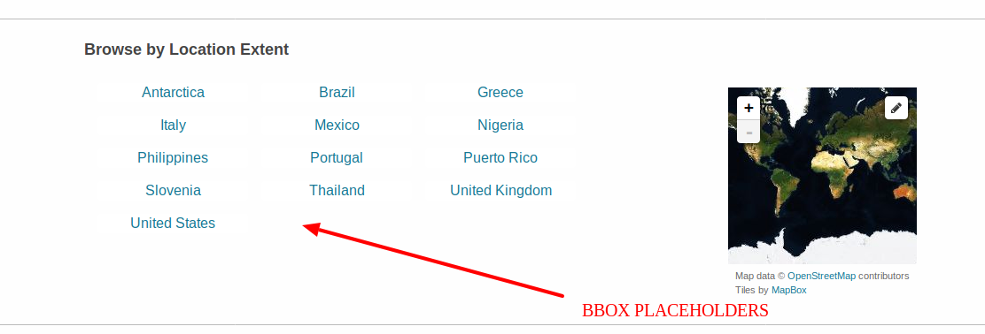
Now, could you kindly provide us with a list of location/POI extent (I don't know... e.g. Mediterranean Sea, Gulf of Mexico, etc.) for GRSF that will be displayed as BBOX placeholders (see the screenshot attached) and directly usable by users in the "Browse by Location Extent" facility?
The BBOX coordinates must be in the EPSG 4326 projection with the format:
LOCATION = minLongitude, minLatitude, maxLongitude, maxLatitude
e.g. for Antartica it could be:
Antarctica=-180,-90,180,-63.2706604895
Updated by Aureliano Gentile almost 7 years ago
Great, thanks!
I think it could be the list of the 19 FAO areas.
I am proposing FAO areas similarly to what we have done in firms home page http://firms.fao.org , later on we may have other type of pre-cooked suggested area filters.
@emmanuel.blondel1@gmail.com what do you think? other suggestions?
In any case, can you add bounding box coordinates for the FAO areas listed hereafter as per Francesco's specifications?
Area 18 (Arctic Sea)
Area 21 (Atlantic, Northwest)
Area 27 (Atlantic, Northeast)
Area 31 ( Atlantic, Western Central)
Area 34 (Atlantic, Eastern Central)
Area 37 (Mediterranean and Black Sea)
Area 41 (Atlantic, Southwest)
Area 47 (Atlantic, Southeast)
Area 48 (Atlantic, Antarctic)
Area 51 ( Indian Ocean, Western)
Area 57 (Indian Ocean, Eastern)
Area 58 (Indian Ocean, Antarctic and Southern)
Area 61 (Pacific, Northwest)
Area 67 (Pacific, Northeast)
Area 71 (Pacific, Western Central)
Area 77 (Pacific, Eastern Central)
Area 81 (Pacific, Southwest)
Area 87 (Pacific, Southeast)
Area 88 (Pacific, Antarctic)
Updated by Aureliano Gentile almost 7 years ago
- File Capture.JPG Capture.JPG added
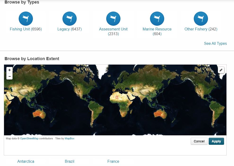
Dear Francesco, while we are waiting for Emmanuel providing the coordinates for the fao areas, I was thinking if that widget can be bigger by default in the homepage.
See attached screenshot for example.
I tested with a couple of colleagues and clearly it has a much better impact if the world map is bigger. With thanks.
Updated by Francesco Mangiacrapa almost 7 years ago
Aureliano Gentile wrote:
Dear Francesco, while we are waiting for Emmanuel providing the coordinates for the fao areas, I was thinking if that widget can be bigger by default in the homepage.
See attached screenshot for example.
I tested with a couple of colleagues and clearly it has a much better impact if the world map is bigger. With thanks.
Hi @aureliano.gentile@fao.org,
I just revised (like you suggested, thanks for this) the Spatial Widget (the map) position and its dimension in the Home Page. You can visit the link https://pre.d4science.org/catalogue to view it.
Any update about the FAO areas?
I would like to add the FAO areas soon and release the Spatial Widget in the Home Page of GRSF Catalogue (as first use case :-))
Updated by Aureliano Gentile almost 7 years ago
Thanks Francesco, but sorry I do not get anything at https://pre.d4science.org/catalogue (after a while loading, it returns an empty page). In any case I trust you have done well.
I asked @emmanuel.blondel1@gmail.com to help with the coordinates and soon we should have them.
 Updated by Emmanuel Blondel almost 7 years ago
Hello, apologies, I hadn't forgot this task, but I have been stuck all the day in devs and an workshop preparation call. Here is the list of FAO major areas with the bounding box in the requested format. For the label, it's processed only with the FAO major area code. I let Aureliano complete this in case he wants more labeling:
18=-180,50.735,180,89.99
21=-82.1588,34.9053,-42,78.1667
27=-44,36,68.5,89.99
31=-97.8883,5,-40,36
34=-40,-6.0975,13.1789,36
37=-5.61,30.2639,41.7761,47.2805
41=-69.6095,-60,-20,5
47=-20,-50,30,-6
48=-84.1019,-83.0411,30,-50
51=30,-45,80,30.5192
57=77,-55,150,23.598
58=30,-72.4269,150,-45
61=-180,15,180,66.4148
67=-175,40,-122.2911,66.1334
71=-180,-28.15,180,20
77=-175,-25,-77.7792,40.5
81=-180,-60,180,-25
87=-120,-60,-65.72,7.2213
88=-180,-85.4703,180,-60
Updated by Aureliano Gentile almost 7 years ago
Thanks Emmanuel, @francesco.mangiacrapa@isti.cnr.it: here the suggested labels together with the coordinates
FAO Major Fishing Areas
Area 18 (Arctic Sea) -180,50.735,180,89.99
Area 21 (Atlantic, Northwest) -82.1588,34.9053,-42,78.1667
Area 27 (Atlantic, Northeast) -44,36,68.5,89.99
Area 31 ( Atlantic, Western Central) -97.8883,5,-40,36
Area 34 (Atlantic, Eastern Central) -40,-6.0975,13.1789,36
Area 37 (Mediterranean and Black Sea) -5.61,30.2639,41.7761,47.2805
Area 41 (Atlantic, Southwest) -69.6095,-60,-20,5
Area 47 (Atlantic, Southeast) -20,-50,30,-6
Area 48 (Atlantic, Antarctic) -84.1019,-83.0411,30,-50
Area 51 ( Indian Ocean, Western) 30,-45,80,30.5192
Area 57 (Indian Ocean, Eastern) 77,-55,150,23.598
Area 58 (Indian Ocean, Antarctic and Southern) 30,-72.4269,150,-45
Area 61 (Pacific, Northwest) -180,15,180,66.4148
Area 67 (Pacific, Northeast) -175,40,-122.2911,66.1334
Area 71 (Pacific, Western Central) -180,-28.15,180,20
Area 77 (Pacific, Eastern Central) -175,-25,-77.7792,40.5
Area 81 (Pacific, Southwest) -180,-60,180,-25
Area 87 (Pacific, Southeast) -120,-60,-65.72,7.2213
Area 88 (Pacific, Antarctic) -180,-85.4703,180,-60
Updated by Francesco Mangiacrapa almost 7 years ago
Hi @aureliano.gentile@fao.org,
about the link copied above (https://pre.d4science.org/catalogue), I apologize, that Catalogue is not accessible from the Internet but from ISTI-CNR LAN only.
However, I just released the facility Spatial Widget in the Home Page of GRSF Catalogue (see at https://bluebridge.d4science.org/group/grsf/data-catalogue).
Let me know...
Updated by Aureliano Gentile almost 7 years ago
With thanks.
regarding the FAO links in https://bluebridge.d4science.org/group/grsf/data-catalogue , I tested a few of them, for example area 88 for which I got as results also records from area 58.4.3.b or 48.4 which I think should not intersect the area 88 bbox.
Am I wrong @emmanuel.blondel1@gmail.com ?
Is it an issue of the query and coordinates, or is it correct due to the dimensions of the bounding boxes?
@francesco.mangiacrapa@isti.cnr.it : are you going to add it also in grsf admin or not?
Updated by Emmanuel Blondel almost 7 years ago
@aureliano.gentile@fao.org It is correct, due to the dimensions of the bounding boxes, which are expressed in the WGS84 (EPSG:4326) system (bounding limits: -180,-90,180,90) that is used to operate the spatial search. In term of bounding box, since the area 88 spreads from -180 to 180 longitude, most of records will of area 48 and 58 will match the spatial query.
Spatial filters are in generally based on bounding box (even in Geonetwork, CSW catalogues, CKAN), although in theory, nothing would prevent to handle real geometries for performing spatial filters, and bypass limitations to the handling of bounding boxes. Typically, the limitation is for geospatial features spreading over the date line (more 'Pacific' centered than Indian/Atlantic ocean centered).
In the past we dealt with this kind of limitation to produce extended layer previews, eg layer http://www.fao.org/geonetwork/srv/en/main.home?uuid=fao-species-map-grn and its preview: http://www.fao.org/figis/geoserver/wms?service=WMS&version=1.1.0&request=GetMap&layers=fifao:UN_CONTINENT2,species:SPECIES_DIST_GRN&bbox=111.5558,-56.8651,185.795,-12.0612&width=600&height=362&srs=EPSG:4326&format=image%2Fpng where we voluntarily increase boundary limits where the information system - here geoserver- allows to do that (> 180 longitude). This is fine for visualization, but unfortunately not for spatial filters. If we would try the same approach, for area 88, that means we would translate all the part close to -180 into coordinates > 180, so even if technically the CKAN spatial filter would work (if permissive as Geoserver, and not taking care of the underlying coordinate reference system in use), you would not match any record close to -180, only those matching the area 88 polygon part close to 180.
Updated by Emmanuel Blondel almost 7 years ago
Last but not least, in general spatial filter is operated with a small map where the user draws its own bounding box without any association to a particular area.
This is the intended usage of spatial filtering.
Assigning areas to their bounding boxes for specific spatial filtering is misleading for the user, and not only for areas crossing the date line. It would be fine actually only for squares/rectangles aligned on lon/axis, it's not the case here.
Updated by Francesco Mangiacrapa almost 7 years ago
Aureliano Gentile wrote:
@francesco.mangiacrapa@isti.cnr.it : are you going to add it also in grsf admin or not?
It is available on GRSF-ADMIN Catalogue also.
Updated by Francesco Mangiacrapa almost 7 years ago
- Status changed from Feedback to Closed

